Sediment Core Research Highlights
The following is a brief listing of research areas where samples from the LDCR collection have played pivotal roles. This excerpt from “Lamont-Doherty Earth Observatory of Columbia University - Twelve Perspectives on the First Fifty Years 1949 – 1999”, summarizes how Doc Ewing’s “core a day” policy and resulting sediment core library, helped shape research at Lamont and beyond:
“Early core studies proved the existence of turbidity currents in the deep ocean, providing an explanation of how canyons are cut on continental shelves… The field of paleoclimatology (the study of past climates) blossomed even more quickly because of the synergy created by the proximity of Lamont's budding geochemistry laboratory [to the nascent core library]. In the early 1950s, Wallace Broecker and J. Laurence Kulp developed radiocarbon dating techniques that could date fossilized shells in… deep-sea cores. In the mid-1950s when Ericson and his associate Goesta Wollin identified an abrupt boundary in a core — marked by an abundance of shells from a species that thrived in warm water above it and none below it — they sent samples to Broecker and Kulp, who dated the boundary at 11,000 years ago, what we now recognize as the boundary that marks the end of the Earth's last glacial period and the beginning of the current warm epoch known as the Holocene Period.
Suddenly scientists could attach dates to various layers in the cores and establish a top-to-bottom chronology of events. They were further aided by evidence in the cores of magnetic reversals in Earth's magnetic field, whose timing was also quickly becoming established. Lamonters Neil Opdyke and James Hays, along with graduate students Billy Glass and John Foster, embarked on a mission to identify a record of magnetic reversals in the cores thus providing a geologic calendar on which climatic events could be superimposed.”
PALEOMAGNETISM
Paleomagnetics is the study of Earth’s magnetic field and how it has changed in the geologic past. Some iron bearing minerals (like magnetite and hematite) align with the Earth’s magnetic field when they crystalize. This orientation is preserved in rocks and can be analyzed to give a record of changes in Earth’s magnetic field going back millions of years. When these minerals erode out of rocks, they act like little compass needles whose orientation can be locked in to sedimentary deposits, providing a stratigraphic record of geomagnetic variations. One of the major changes that has been recorded in these rocks and sediments is the reversals of the magnetic field: when magnetic North and South are flipped.
Several cores in the LDCR collection including - V28-179PC, V28-238PC, and V28-239PC – were instrumental in showing how paleomagnetics can be used for stratigraphic correlation. Since reversals are global and nearly instantaneous, paleomagnetic stratigraphy is a powerful tool for correlating and dating deep-sea cores. (1) Reversals were also linked (in time) to the extinction of some microfossil species: “The establishment of the true chronostratigraphic relationships of these selected microfossil species allows us to date zonations of previous authors and provides absolute dates that can be used in worldwide correlation of marine sediments.” (3)
- Opdyke, N. D., Glass, B., Hays, J. D., and Foster, J., 1966, Paleomagnetic study of Antarctic deep-sea cores: Science, v. 154, no. 3747, p. 349-357.
- Ninkovich, D., Opdyke, N. D., Heezen, B. C., and Foster, J. H., 1966, Paleomagnetic stratigraphy, rates of deposition and tephrachronology in North Pacific deep-sea sediments: Earth and Planetary Science Letters, v. 1, p. 476-492.
- Hays, J. D., Saito, T., Opdyke, N. D., and Burckle, L. H., 1969, Pliocene-Pleistocene sediments of the equatorial Pacific and their paleomagnetic, biostratigraphic and climatic record: Geological Society of America Bulletin, v. 80, p. 1481-1514.
- Shackleton, N. J., and Opdyke, N. D., 1973, Oxygen isotope and paleomagnetic stratigraphy of equatorial Pacific core V28-238: Oxygen isotope temperatures and ice volumes on a 10*5 and 10*6 year scale: Journal of Quaternary Research, v. 3, p. 39-55.
- Shackleton, N. J., and Opdyke, N. D., 1976, Oxygen-isotope and paleomagnetic stratigraphy of Pacific core V28-239: Late Pliocene to latest Pleistocene: Geological Society of America Memoir, v. 145, p. 449-464.
- Shackleton, N. J., and Opdyke, N. D., 1977, Oxygen isotope and palaeomagnetic evidence for early Northern Hemisphere glaciation: Nature, v. 270, p. 216-219.
- Raisbeck, G. M., Yiou, F., Bourles, D., and Kent, D. V., 1985, Evidence for an increase in cosmogenic 10Be during a geomagnetic reversal: Nature, v. 315, p. 315-317.
MILANKOVITCH CYCLES - CLIMAP
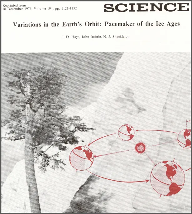
CLIMAP (Climate: Long range Investigation, Mapping, and Prediction) was an international effort, launched in 1971, to reconstruct the history of ocean changes deep into the past. Spearheaded by Jim Hays and John Imbrie, CLIMAP researchers looked at various climatic signals (including faunal successions and clay mineralogies) in hundreds of sediment cores. The CLIMAP team proved that changes in astronomical cycles (more specifically, changes in the Earth's eccentricity, precession and tilt) triggered Earth's glacial cycles. The seminal paper from this project, “Variations in the Earth’s Orbit: Pacemaker of the Ice Ages”, used data from two cores – RC11-120PC and ELT49-018PC.
1. Hays, J. D., Imbrie, J., and Shackleton, N. J., 1976, Variations in the Earth's Orbit: Pacemaker of the Ice Ages: Science (American Association for the Advancement of Science), 12/10/1976, ISSN: 0036-8075, Volume 194, Issue 4270, p. 1121.
TURBIDITY CURRENTS
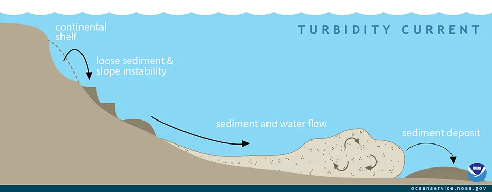
A turbidity current is an underwater landslide on the continental shelf and slope. Sediments and debris start to slide downhill as the result of an earthquake or other instability, and mix with the overlying water. This flow of debris-laden water results in a distinct pattern of deposition called a turbidite. What makes turbidites stand out in the sedimentary record is the tell-tale “fining upwards” sequence where coarser material falls out of the flow and is deposited first with each subsequent layer above consisting of finer and finer material. These sequences were first documented on the ocean floor by Dave Ericson, Maurice Ewing and Bruce Heezen using cores from the LDCR collection taken on several R/V Atlantis and R/V Caryn cruises.
- Ericson, D. B., Ewing, M., Heezen, B. C., 1952, TURBIDITY CURRENTS AND SEDIMENTS IN NORTH ATLANTIC, BULLETIN OF THE AMERICAN ASSOCIATION OF PETROLEUM GEOLOGISTS, VOL. 36. NO. 3 (MARCH, 1952) , PP. 489-511.
- Heezen, B. C. and Ewing, M., 1952, Turbidity Currents and Submarine Slumps, and the 1929 Grand Banks Earthquake, American Journal of Science, Vol. 250, December 1952, pp. 849-873.